Richmond 300: A Guide for Growth
Planning and Policy
900 E. Broad St., Room 511
Richmond, VA 23219
Monday - Friday 8 a.m. - 5 p.m.
Awarded the 2021 Daniel Burnham Award for a Comprehensive Plan from the American Planning Association
This award recognizes an innovative plan that helps create a more prosperous and equitable community for current and future residents and raises awareness of the importance of planning. "Richmond is a prime example of how planning can help a community begin to overcome past wrongs like redlining and practices that unfairly excluded specific populations from access to opportunity," said Kristen Asp, AICP, 2021 APA Awards Jury Chair. "This plan, combined with their laser focus on implementation, is an example for other communities around the country on how planning can and should address systemic racism." Click here to learn more info about the award!
Click HERE to receive updates about the implementation of Richmond 300.
Richmond 300 Guide for Developers
Are you going through a development process or land use review? Use this guide to understand how to interpret Richmond 300's Future Land Use, Nodes, Future Transportation, and Goals & Objectives to inform your developments.
Adopted by City Council on December 14, 2020
Amended July 10, 2023
Final Amended Plan Adopted by City Council on September 26, 2023
City-Wide Vision:
In 2037, Richmond is a welcoming, inclusive, diverse, innovative, sustainable, and equitable city of thriving neighborhoods, ensuring a high quality of life for all.
Plan Implementation
The 17 goals, 73 objectives, and 415 strategies outlined in this plan provide guidance for City staff, local businesses, the development community, non-profits, and the public to use as Richmond continues to grow and change over the next 20 years. The expansive nature of the Master Plan, touching on a myriad of topics shaping Richmond's growth, can make it difficult to implement. Chapter 7 of the Plan outlines how to implement Richmond 300 to reach the City's goals established in support of the City-wide vision.
Metrics
Key benchmarks for the City to track as it implements the Master Plan. The metrics are not tied to specifics goals in the plan but rather are benchmarks to see how the city is changing over time.
Download PDF: Metrics (111 KB)
6 Big Moves
Wide-reaching initiatives that touch many goals of the plan that will set Richmond on track to reach its vision for 2037. The six Big Moves intentionally seek to expand equity, increase the sustainability of our city, and beautify our city.
- Re-Write the Zoning Ordinance: Direct growth to appropriate areas while maintaining existing neighborhoods as well as creating new authentic neighborhoods adjacent to enhanced transit.
- Re-Imagine Priority Growth Nodes: Target growth in jobs and population to Downtown, Greater Scott’s Addition, Route 1 Corridor, Southside Plaza, and Stony Point Fashion Park.
- Expand Housing Opportunities: Encourage the development of housing options throughout the city to expand the geography of opportunity by de-concentrating poverty.
- Provide Greenways & Parks for All: Develop parks and greenways so that by 2037 100% of Richmonders live within a 10-minute walk of a park.
- Reconnect the City: Cap highways to reknit neighborhoods destroyed by interstates, build/improve bridges, introduce street grids, and make the city easier to access by foot, bike, and transit.
- Realign City Facilities: Improve City buildings (schools, libraries, fire stations, police stations, etc.) to provide better services in efficient, shared-use, accessible facilities to better match and serve the growing city.
Download PDF: Big Moves (268 KB)
Reporting
Annual reporting will help implement the plan and communicate the progress with other City departments and with the general public. Every year PDR staff should create a Richmond 300 Annual Report, post the Annual Report on its website, and present the Annual Report to the City Planning Commission and City Council.
What is a master plan?
The Master Plan (also known as the Comprehensive Plan) establishes a vision for the growth of the City and outlines place-based policy recommendations to guide its physical development. The City Planning Commission uses this document as a guide for decision making. The primary tools for implementing the vision set forth in the Master Plan are the capital improvement budget, public projects, and the zoning ordinance. The Code of Virginia (§ 15.2-2223) requires local planning commissions to establish a comprehensive plan and review said plan every five years.
Why does the city need a master plan?
The City is only 62.5 sq. miles. The Master Plan helps determine how to plan for growth within the limited footprint of the city. The Master Plan provides guidance on re-zoning land, allocating capital improvement funding, public infrastructure and building projects, and economic development. The Master Plan sets policy related to housing, economic development, infrastructure, zoning, land use, transportation, and more. The previous city-wide Master Plan was adopted in 2001.
Why is it called Richmond 300?
Richmond was founded in 1737. As we look forward to the city’s 300th anniversary in 2037, how do we want Richmond to look, feel, and work? How do we want our city to feel and grow over the next 20 years so that when we celebrate our 300th anniversary we are proud of where we are? Richmond 300: A Guide for Growth will articulate our vision for Richmond in 2037 and outline recommendations to get us there.
Download Appendix B: Process (688 KB)
Phase 4: Implement the Plan (January 2021-January 2026)
As soon as City Council voted to adopt the plan in December 2020, PDR staff could start implementing the goals in Richmond 300. Among the hundreds of strategies in the plan, 6 "Big Moves" emerged as the most pressing priorities for staff to accomplish in the next 5 years. Already, several small area plans in line with Richmond 300 are underway. Around January of 2026, Richmond 300 will be revisited in order to evaluate metrics and determine what should be adjusted, per the requirement of the Code of Virginia.
Phase 3: Refine and Adopt the Plan (May 2020-December 2020)
In the midst of the COVID-19 pandemic, the team had to pivot to a virtual community engagement strategy in this important phase of the process. During Community Consultation #3: Draft Plan (June-July 2020), we led 11 virtual summits showing the contents of the draft plan and received hundreds of comments. For several months afterwards, the public comments helped to refine the plan. The Pre-Final Plan was approved by the Advisory Council and released in September 2020. In October 2020, the City Planning Commission unanimously voted to adopt the plan; it was subsequently passed onto the City Council, who unanimously voted to adopt the plan in December 2020.
Download PDF: Community Consultation #3 Report (199 KB)
Download PDF: Community Consultation #3 Emails, Letters, and Comments (7 MB)
Phase 2: Developing the Plan (December 2018-April 2020)
The actual content of Richmond 300 was created during the Plan Development phase. During Community Consultation #1: Visioning (September-October 2018), the team asked the community for their vision for Richmond in 2037 and big ideas to get there. We summarized all the input we received in the Community Consultation #1 Report (download below). Based on this input, we developed one communal vision statement and several goals. The Advisory Council established five Working Groups. The Working Groups developed strategies and actions to reach the goals during meetings in 2019. The draft maps, goals, and strategies were presented for community input during Community Consultation #2: Recommendations (September-November 2019). The community feedback received is summarized in the Community Consultation #2 Report (download below). City staff incorporated community feedback and wrote the draft Richmond 300 document.
Download PDF: Community Consultation #1 Report (2 MB)
Download PDF: Community Consultation #2 Report (241 KB)
Download PDF: Community Consultation #2 Letters, Emails, and Comments (3 MB)
Download Excel Spreadsheet: Community Consultation #2 Survey Responses (307 KB)
Phase 1: Defining the Plan (May 2017-November 2018)
During the pre-planning phase, the City set the stage for the planning process by conducting various tasks such as hiring sub-consultants, establishing the Technical Team and Advisory Council, and attending over 75 community meetings. Extensive data was collected in order to develop several preliminary reports such as the Land Use, Housing, and Demographic Analysis, the Urban Design Typology Analysis, and the Insights Report (find these in the "Supporting Reports tab" above). Finally, the team developed a brand identity and created multiple social media channels, a dedicated website, email distribution list, and hosted a launch event.
City-Wide Vision
In 2037, Richmond is a welcoming, inclusive, diverse, innovative, sustainable, and equitable city of thriving neighborhoods, ensuring a high quality of life for all.
Future Land Use
Download PDF: Future Land Use (28 MB)
Future land use designations are both visionary and strategic, and include language about how the area should look and feel in the future, but do not specify what an owner can or cannot legally do with their property.
Residential: Neighborhood consisting primarily of single-family houses on large- or medium-sized lots more homogeneous in nature.
Neighborhood Mixed-Use: Existing or new highly walkable urban neighborhoods that are predominantly residential with a small, but critical, percentage of parcels providing retail, office, personal service, and institutional uses.
Community Mixed-Use: Cluster of medium-density, walkable commercial and residential uses that provide neighborhood services to nearby residential communities and sometimes feature regional attractions.
Corridor Mixed-Use: Found along major commercial corridors and envisioned to provide for medium- to medium-high-density pedestrian- and transit-oriented development.
Industrial Mixed-Use: Formerly traditional industrial areas that are transitioning to mixed-use because of their proximity to growing neighborhoods and changes in market conditions. These areas may still retail some light industrial uses.
Destination Mixed-Use: Key gateways featuring prominent destinations, such as retail, sports venues, and large employers, as well as housing and open space. Located at the convergence of several modes of transportation, including Pulse BRT or other planned transit improvements.
Downtown Mixed-Use: Central business district of the Richmond region features high-density development with office buildings, residential buildings, and a mix of complementary uses, including regional destinations in a highly-walkable urban environment.
Industrial: Manufacturing and production areas that primarily feature processing, research and development, warehousing, and distribution.
Institutional: Public and quasi-public entities, such as local, state, and federal government, hospitals, universities, schools, and religious institutions.
Public Open Space: Public and quasi-public parks, recreation areas, open spaces, and cemeteries.
Future Land Use Map
Click here for "Future Land Use" interactive web map
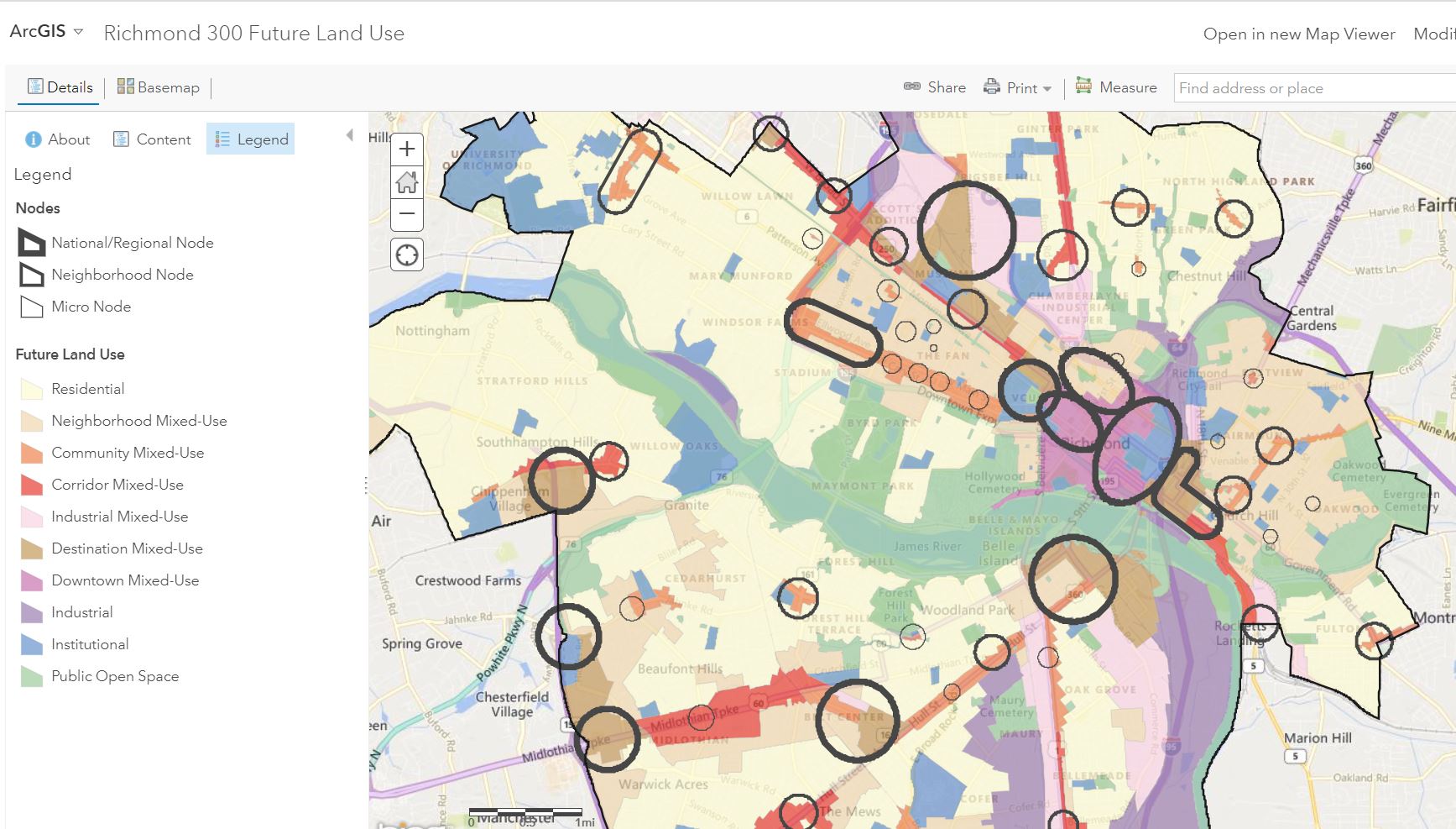
Nodes
Download PDF: Appendix C - Other Nodes (22 MB)
Nodes are places in Richmond where people and jobs are today and continue to grow into the future. Nodes are the places of convergence of many uses and include offices, shopping, housing, and/or public gathering places as well as access to multiple modes of transportation.
- Regional/National Node: A center with significant cultural, entertainment, government, and business destinations as well as shopping, housing, and unique place-based attractions.
- Neighborhood Node: A local crossroads typically within or next to larger residential areas that offers goods and services to nearby residents, employees, and visitors.
- Micro Node: A notable place within a neighborhood that generally provides goods and services to the immediate residents but may attract visitors.
Nodes Web Map
Click here for "Nodes" interactive web map

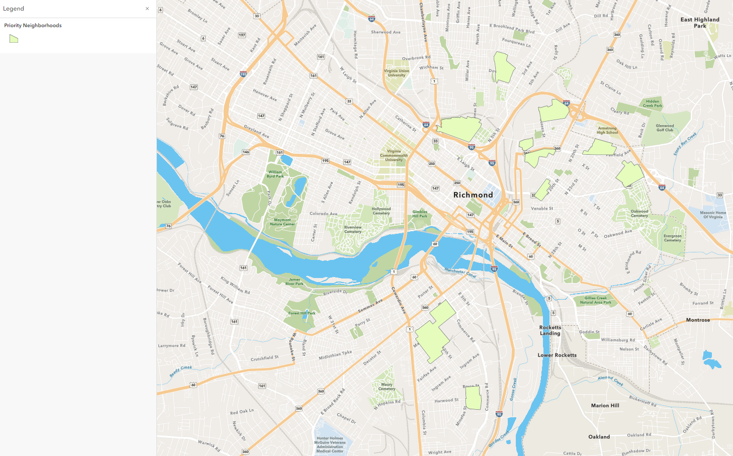
Priority Neighborhoods
Download PDF: Priority Neighborhoods (12 MB)
Priority Neighborhoods are the primary focus of investment for the City of Richmond and the Richmond Redevelopment and Housing Authority. Priority Neighborhoods consist of public housing and land owned or recently transferred by RRHA that play an integral role in communities across the city.
Priority Neighborhood Web Map
Click here for "Priority Neighborhoods" interactive web map
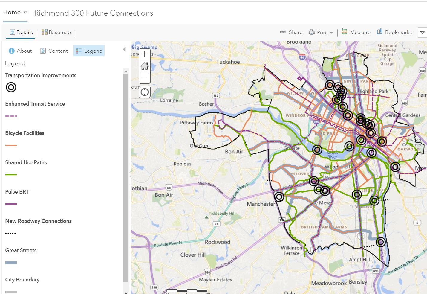
Future Connections
Download PDF: Future Connections (4.2 MB)
The Future Connections Map depicts the envisioned transportation networks that will provide access to and among
Nodes.
- Great Streets: significant entrances to the city and serve as major connectors between city destinations.
- Greenways/Shared-Use Paths: universally accessible paved paths that are a minimum of 8-feet wide and are intended for pedestrians, cyclists, and other non-vehicle users. Examples of greenways in Richmond are the Canon Creek Greenway and the Virginia Capital Trail.
- On-Street Bike Facilities: may include a buffered bike lane, protected bike-lane, cycle track, or bike/walk boulevard; however, a sharrow is considered inadequate for on-street bicycle protection.
- Enhanced Transit Routes: transit corridors envisioned to have high-frequency service (ideally every 10 minutes, but likely 15 minutes) and longer service hours (ideally 24/7, but likely less).
- Street Connections, Interchanges, and Bridges: locations where implementing a street grid may be appropriate, as well as locations for highway interchange improvements, bridge rehabilitation or replacement, and new bridge connections.
Future Connections Map
Click here for "Future Connections" interactive web map
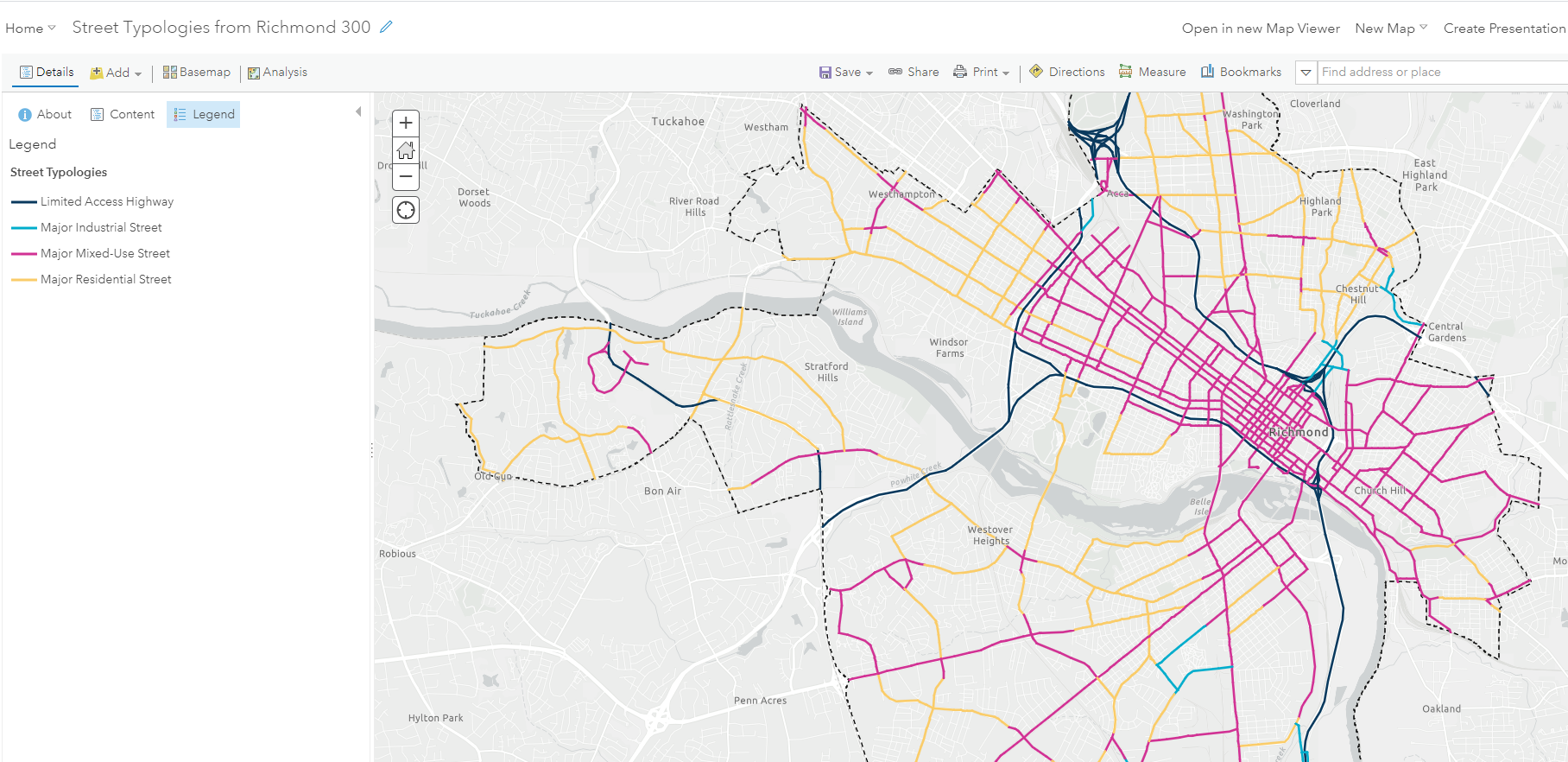
 Street Typologies Map
The character of a street changes as the adjacent land uses change. The Street Typology Map depicts four Street Typologies which are applied to the most frequently-used streets (those with high annual average daily traffic (AADT)). When planners, developers, and transportation engineers plan for changes to buildings and the street along the streets identified in this map, they should all work closely together to ensure the street design meets the needs of the envisioned land uses:
- Major Mixed-Use Streets: Carry high volumes of vehicles, pedestrians, and bicycles, through commercial and mixed-use areas; Prioritize use and density-scaled sidewalks and crosswalks; Require form elements, such as buildings to the street with parking in the rear, as well as building windows and entrances on the street; Incorporate streetscape features, such as trees, benches, and trash receptacles; Ideal locations for transit routes and transit stops; Prioritize the curbside for walking, bicycling, transit, and short-term parking access and loading for local shops and restaurants
- Major Residential Streets: Carry high volumes of vehicles, as well as pedestrians and bicycles, through residential neighborhoods; Prioritize for creating sidewalks and crosswalks; Install street trees as a buffer between sidewalk and street; Ideal locations for transit routes and transit stops; Ensure low street speed by utilizing traffic calming measures
- Major Industrial Streets: Carry high volumes of vehicles, including a high percentage of truck traffic, through industrial areas; Prioritize sidewalks and crosswalks; Install street trees with a buffer between sidewalk and street; Ideal locations for transit routes and transit stops
- Limited Access Highways: Interstate, Downtown Expressway, Chippenham Parkway, and other limited-access highways that do not allow for non-vehicular access
Chapter 2: High Quality Places
Download PDF: Chapter 2 - High-Quality Places (25 MB)
Topic Vision
Richmond is a well-designed city of communities interconnected by a network of Nodes, public facilities, and open spaces providing services to residents, businesses, and visitors. As the Capital of the Commonwealth, Richmond leads the region in high-quality business and residential growth. Richmond's unique neighborhoods and districts, both historical and new, support a diversity of uses, the equitable accommodation of all phases of life, and the efficient use of land to promote sustainable and healthy lifestyles.
Goal 1: Complete Neighborhoods - Establish a city of complete neighborhoods that have access to Nodes and Priority Neighborhoods connected by major corridors in a gridded street network.
Includes 18 strategies related to:
- Rezoning the city
- Developing and adopting small area plans
- Supporting the growth of jobs and housing in Nodes and Priority Neighborhoods
- Maintaining and improving primarily residential areas
Goal 2: City-Owned Assets - Efficiently manage City-owned land and facilities.
Includes 12 strategies related to:
- Aligning new facilities and improving existing City-owned facilities
- Creating a real estate acquisition and disposition strategy
- Planning for the expansion and improvement of utilities
Goal 3: Historic Preservation - Support growth that preserves the historical urban fabric and enhances understanding of Richmond's multi-faceted past.
Includes 23 strategies related to:
- Preserving culturally, historically, and architecturally significant buildings, sites, structures, neighborhoods, cemeteries, and landscapes
- Reducing the demolition of historic buildings
- Broadening the constituency for historic preservation
Goal 4: Urban Design - Establish a distinctive city comprising architecturally significant buildings connected by a network of walkable urban streets and open spaces to support and engaging built environment.
Includes 36 strategies related to:
- Creating and preserving high-quality, distinctive, and well-designed neighborhoods and Nodes
- Integrating public art into the built environment
- Increasing neighborhood access to, and through, a well-designed network of open spaces
- Increasing Richmond's walkability
Goal 5: Planning Engagement - Foster a planning engagement culture that effectively and equitably builds people's capacity to organize to improve the city and their neighborhoods.
Includes 9 strategies related to:
- Increasing public knowledge of planning processes
- Engaging City staff, appointed commissioners, and elected officials in the planning process
Chapter 3: Equitable Transportation
Download PDF: Chapter 3 - Equitable Transportation (24 MB)
Topic Vision
Richmond prioritizes the movement of people over the movement of vehicles through a safe, reliable, equitable, and sustainable transportation network. Walking, biking, and transit options are the most convenient and used forms of transportation in Richmond, thereby improving the natural environment and our health. Richmond's multi-modal transportation system is high-quality and easy for all people to use regardless of income and physical abilities, seamlessly connecting Richmond neighborhoods and attractions to each other, the region, and the nation.
Goal 6: Land Use and Transportation Planning - Align future land use and transportation planning to support a sustainable and resilient city.
Includes 6 strategies related to:
- Increasing the number of residents and jobs at Nodes, Priority Neighborhoods, and along enhanced transit corridors
Goal 7: Vision Zero - Systematically change the built environment to shift our safety culture and ensure that individuals are not killed or seriously injured on city streets.
Includes 4 strategies related to:
- Reducing all traffic-related deaths
Goal 8: Non-Car Network - Enhance walking, biking, and transit infrastructure to provide universal access to all users, prioritizing low-income areas and areas within the high-injury street network.
Includes 38 strategies related to:
- Improving the pedestrian experience
- Increasing the mileage of greenways
- Expanding and improving on-street networks and amenities serving bicycles
- Increasing transit service
- Increasing the number of intercity travel options
- Increasing the number of employers implementing Transportation Demand Management (TDM)
Goal 9: Streets, Bridges & Interchanges - Build and improve streets and bridges to expand connectivity for all users.
Includes 25 strategies related to:
- Improving streets for all users
- Improving and creating bridges
- Increasing the mileage of alleyways
- Strengthening the street network
- Improving 80% of street pavement to an index of good or better
- Implementing parking strategies
Goal 10: Emerging Transportation Technologies - Incorporate emerging technology into the transportation network in ways that seek to reduce single-occupancy vehicle use and reduce greenhouse gas emissions.
Includes 18 strategies related to:
- Expanding and maintaining the Richmond Signal System
- Developing programs to manage new mobility technologies
- Utilizing technology to reduce vehicle miles traveled related to circling the block
- Increasing the number of low emission vehicles
Chapter 4: Diverse Economy
Download PDF: Chapter 4 - Diverse Economy (4 MB)
Topic Vision
Richmond is home to a variety of businesses and industries that offer opportunities for quality employment and capital investment. Richmond is a first-choice location for businesses and investment because the city's transportation, housing, cultural, outdoor, commercial, and institutional amenities create a vibrant city. Richmonders of all income levels have opportunities for life-long learning and skill-building.
Goal 11: Businesses and Jobs - Foster an environment that supports the growth of existing and new small, medium, and large businesses, focusing on Nodes, Priority Neighborhoods, major corridors, and industrial centers.
Includes 28 strategies related to:
- Retaining, creating, and attracting employers
- Equitable economic development strategies
- Small businesses, start-ups, and women-owned and minority businesses
- Future industrial users
- Branding and marketing Nodes and Priority Neighborhoods
Goal 12: Tourism - Develop tourism and attractions to further elevate Richmond's image and to continue to delight existing and future residents, employees, and visitors.
Includes 11 strategies related to:
- Richmond's tourism attractions
- Hosting regional, national, and international events
- Availability and options for lodging
- Improving hospitality and visitor facilities/services
Goal 13: Anchor Institutions - Leverage institutions to strengthen job sectors and collaborate on land planning.
Includes 4 strategies related to:
- Cooperative relationships between institutions and neighborhoods
- Careful consideration of land resources
Chapter 5: Inclusive Housing
Download PDF: Chapter 5 - Inclusive Housing (9 MB)
Topic Vision
Richmond is a city where all people can access quality housing choices. By preserving and increasing housing options, Richmond supports existing and new residents, regardless of income. As the city grows, Richmond provides options to existing residents, preventing involuntary displacement and reducing housing disparities. Housing is the foundation of inclusive Richmond neighborhoods that are walkable with adequate linkages to services, goods, and open spaces.
Goal 14: Inclusive Housing - Preserve, expand, and create mixed-income communities by preserving existing housing units and developing new ones - both renter- and owner-occupied - throughout the city.
Includes 54 strategies related to:
- Increasing city-wide awareness of the importance of integrating housing at all income levels
- Ensuring that homelessness is rare, brief, and one-time
- Creating 10,000 new affordable housing units
- Mixed-income communities along enhanced transit corridors
- Encouraging more housing types throughout the city
- Transforming Richmond Redevelopment and Housing Authority (RRHA) public housing properties
- Re-imaging the future of manufactured home parks
- Preventing involuntary displacement
- Aging in place
Chapter 6: Thriving Environment
Download PDF: Chapter 6 - Thriving Environment (13 MB)
Topic Vision
Richmond is a sustainable and resilient city with healthy air, clean water, and a flourishing ecosystem. Carbon emissions are low, air and water quality are high, and city-wide solid waste production is minimal. The City is positively adapting to the effects of a changing climate, with a built environment that enhances and protects natural assets, including the James River. All residents have equitable access to nature and a healthy community.
Goal 15: Clean Air - Improve air quality within the city and the region, achieve a 45% reduction in greenhouse gas emissions within the city by 2030, and achieve net zero greenhouse gas emissions in the city by 2050 via RVAgreen 2050.
Includes 27 strategies related to:
- Reducing air pollution related to transportation
- Reducing air pollution related to City infrastructure and facilities
- Reducing air pollution related to private buildings
- Reducing the amount of waste going into landfills
Goal 16: Clean Water - Improve local water quality and manage the built environment to enhance and protect natural assets such as the James River.
Includes 29 strategies related to:
- Restoring all streams into healthy riparian areas
- Placing an additional 100 acres under conservation easement
- Reducing water consumption by 10% per capita
- Increasing green stormwater infrastructure
Goal 17: Resilient & Healthy Communities - Positively adapt to the effects of a changing climate via RVAgreen 2050, and ensure that all residents have equitable access to nature and a healthy community.
Includes 45 strategies related to:
- Increasing the percentage of Richmonders within a 10-minute walk of quality open space to 100%
- Increasing the city-wide tree canopy from 42% to 60%
- Reducing the urban heat island effect
- Expanding access to the local healthy food system
- Reducing the effect from heavy rainfall events and sea level rise
- Increasing the resiliency of infrastructure and community assets
Insights Report (September 2018)
The Insights Report provides a summary of data and trends that shape the growth of Richmond, which helped planners shape and develop Richmond 300. It is the most foundational document to Richmond 300 - a must-read if you want to understand the data and analysis that set the stage for the Master Plan.
Download PDF: Insights Report (13 MB)
CURA Reports (March 2019)
The Center for Urban and Regional Analysis (CURA) at Virginia Commonwealth University (VCU) authored two background reports in support of Richmond 300:
1. Land Use, Housing, and Demographic Analysis: This report summarizes Census data showing how Richmond has changed overtime. It also has rough population estimates and anticipated land use and housing demand. The report also presents an analysis of six historic commercial areas in Richmond and states how many more median-income households would be needed in the neighborhood to support a neighborhood grocery store.
Download PDF: CURA Land, Use, Housing, and Demographic Analysis (6 MB)
2. Urban Design Typologies: This report categories Richmond land area by urban design typologies and also presents a short history of the development of Richmond.
Download PDF: CURA Urban Design Typologies (8 MB)
Parking Study (August 2019)
As part of Richmond 300: A Guide for Growth, the city-wide Master Plan update, the City of Richmond's Dept. of Planning and Development Review commissioned Desman to review parking conditions and provide recommendations in seven areas in Richmond.
The major objectives of the Parking Study were:
- Support continued redevelopment of the city of Richmond while balancing the multi-modal transportation demands of its growing population.
- Provide existing parking conditions data.
- Develop policy recommendations to address parking.
- Create communications materials to present recommendations.
- Suggest policy that could be applied to other parts of the city.
Download PDF: Parking Recommendations (2 MB)
Download PDF: Parking Implementation Matrix (67 KB)
Scott's Addition Circulation Study (July 2019)
The Department of Public Works contracted VHB, an engineering consultant, to develop a circulation study for Scott's Addition to provide recommendations to improve circulation and implement multimodal, vision zero, and complete streets concepts.
Download PDF: Scott's Addition Circulation Study (6 MB)
Download PDF: Scott's Addition Circulation Study Appendices (7 MB)(link broken 20240118)