
Address: 900 E. Broad St.,
Room 115
Richmond, VA 23219
Phone: (804) 646-4646
For gas leaks, leave the area and call 911
Follow us on our social media channels for news and updates:
![]()
![]()
![]()
![]()
For other news, check out our news page:
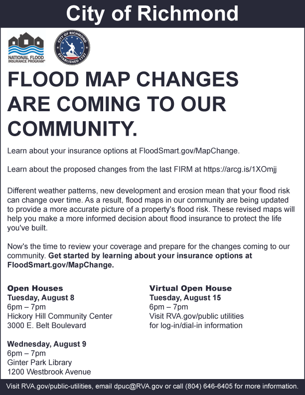
Floodplain Management
What is a floodplain?
A floodplain is a natural low lying area next to a river or stream. A floodplain helps spread out and slow down the water during rain events. It is an important part of our water system and effects water quality, wildlife habitat, and stormwater runoff. Building or alterations in the floodplain can cause detrimental effects both upstream and downstream. It is important you know your level of risk and protect yourself, your family and your property.
Can I build in a floodplain?
Building in the floodplain is discouraged in the City. There are strict guidelines before development can occur in the floodplain. All areas of the City have flood elevation protection requirements. Alterations to existing development requires flood proofing to protect from property damage during flooding events. It is important to know that any residential development in the floodplain will be required to carry flood insurance.
To find out more about building in a floodplain, please contact the Water Resources Division at (804)646-7586.
What Causes Flooding?
- Heavy rainfall and large storms can cause flooding events. Excessive amounts of rainfall can happen at any time of the year. Flooding causes high risk to people and properties.
- Flash floods, a rapid flooding of low-lying areas caused by intense rainfall or thunderstorms can tear out trees and destroy building and bridges.
- Snow melt can produce large amounts of runoff because the ground is frozen and hard. Water cannot penetrate or be reabsorbed into the ground -- producing excess runoff, taking pollutants and debris with it.
- New development can change the amount of impervious area that does not absorb rain. This increase in water running across the surface of the ground can cause streams and rivers to become overtopped when historically they did not before new buildings and parking lots were built.
- Blocked inlets can become clogged with debris from trash, sediment, leaves and lawn clippings. Inlets full of trash don't have the capacity to take stormwater away, causing flooding, driving hazards and property damage even during small rain events.
How Can I Protect my Property?
If you build in a floodplain or purchase a property in the floodplain and carry a mortgage, you may be required by your lender to carry flood insurance. Flood insurance is not included in your property insurance. Only the NFIP provides flood insurance. In Virginia it is the property owner's responsibility to find out if a structure is in the floodplain.
Flood Insurance
The City of Richmond participates in the national Flood Insurance Program and has Flood Insurance Rate Maps (FIRMs) of floodplains within the city. Under this program, federally insured or regulated institutions must require flood insurance policies on all new loans for structures in mapped special flood hazard areas (SFHA) recognized by the Federal Emergency Management Agency (FEMA).
To find out more about building in a floodplain, please contact the Water Resources Division at (804) 646-7586.
Flood Protection
The local flood protection system in Richmond has a total length of 17,327 feet (3.28 miles) and protects 750 acres valued at approximately $153 million. It consists of:
- A partially rip-rapped earthen levee
- A concrete floodwall
- Three overlooks (9th & Semmes, Hull & Mayo Bridge, and 12th & Byrd)
- Six roadway closures
- Six railroad closures
- Four personnel closure locations
- Two combined roadway and railroad closures
- Three pump stations
- Three designated ponding areas
The southside alignment comprises three components:
- One earthen levee, approximately 9,000 feet long
- A combination bin wall/levee, approximately 2,000 feet long
- A concrete floodwall, approximately 2,000 feet long
The line of protection extends from just west of the Manchester Bridge, continues along the river's edge to the west side of Interstate 95, turns south, then west, crossing the CSX Railway mainline tracks, and tying into high ground at Goodes Street.
Interior runoff from the watershed in excess of the capacity of the pump station during high river stages will be collected or backed up into the ponding areas. After the river recedes, all ponding areas will drain by gravity through their respective outlets.
The northern alignment is comprised of one component, concrete floodwall which is approximately 4,500 feet long with height variations from five to 29 feet.
The line of protection extends across the mouth of Shockoe Valley to 12th Street. The wall is designed to protect those areas located behind it against a flood with an average recurrence interval of 280 years. The project was dedicated on October 21, 1994, at a cost of $143 million.
Our FEMA (Federal Emergency Management Agency) maps are available online.
Links
- Floodplain Map
- FEMA National Flood Plain Insurance
- FEMA Map Service Center
- FEMA Elevation Certificate and Instructions
- The Association of State Floodplain Managers (ASFPM)