Address: 900 E. Broad St.,
Room 115
Richmond, VA 23219
Phone: (804) 646-4646
For gas leaks, leave the area and call 911
Follow us on our social media channels for news and updates:
![]()
![]()
![]()
![]()
For other news, check out our news page:
Chesapeake Bay Protection Areas
The City of Richmond is committed to helping the Commonwealth improve and preserve water quality for the 64,000 square mile watershed that flows to the Chesapeake Bay.
The Chesapeake Bay program was adopted in 1981 as required by Virginia General Assembly to create and preserve buffer areas around local streams and rivers to help improve water quality.
New and redevelopment construction projects within these designated Chesapeake Bay Protection Areas (CBPAs) are required to provide some type offset or mitigation to improve the quality of the water before the runoff enters local waterways which ultimately flow to the Bay.
When developing within a CBPA there are some key points to remember:
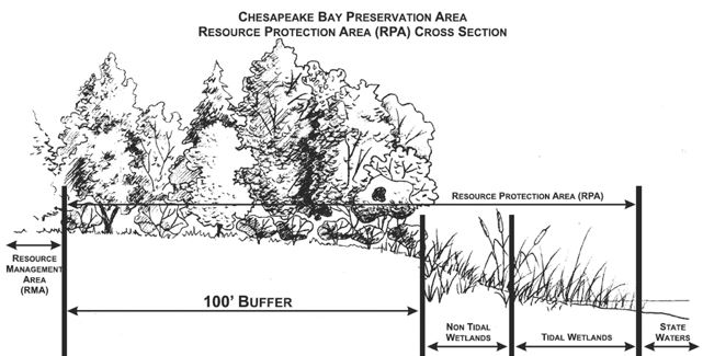
Resource Management Area
A Resource Management Area (RMA) is contiguous to the entire inland boundary of a Resource Protection Area (RPA). The following land categories shall be considered for inclusion in the Resource Management Area and, where mapping resources indicate the presence of these land types contiguous to the resource protection area, should be included in designations of RMAs:
- 100-year floodplains
- Highly erodible soils including steep slopes
- Non-tidal wetlands not included in the RPA
- 500-foot buffers (protect RPAs and those other areas listed)
- 600-foot buffers outward from the center of the stream in areas where the RMA has no site specific evaluation.
Resource Protection Area
A Resource Protection Area (RPA) consists of lands adjacent to water bodies with perennial flow that have an intrinsic water quality value due to the ecological and biological processes they perform or lands that are sensitive to impacts which may cause significant degradation to the quality of state waters. The City has included the following areas:
- Tidal wetlands
- Non-tidal wetlands contiguous to tidal wetlands or water bodies with perennial flow
- Tidal shores
- Other land considered necessary for water quality protection
- Buffered areas 100 feet landward of and adjacent to those listed above.
An Intensely Developed Area (IDA) is an overlay to the RPA, this category includes "areas of existing development and infill sites where little of the natural environment remains." Development in an IDA is treated as redevelopment, in which case the performance requirement is for a ten percent (10%) reduction in nonpoint source pollution where runoff is not already treated by a BMP.
Water Quality Impact Assessment (WQIA) is a narrative that identifies the impacts of proposed development on water quality and lands in the Resources Protection Areas consistent with the goals and objectives of the Clean Water Act, City Code, and the city's programs, and to determine specific measures for mitigation of those impacts. A WQIA is required for all development and encroachments into a RPA.